
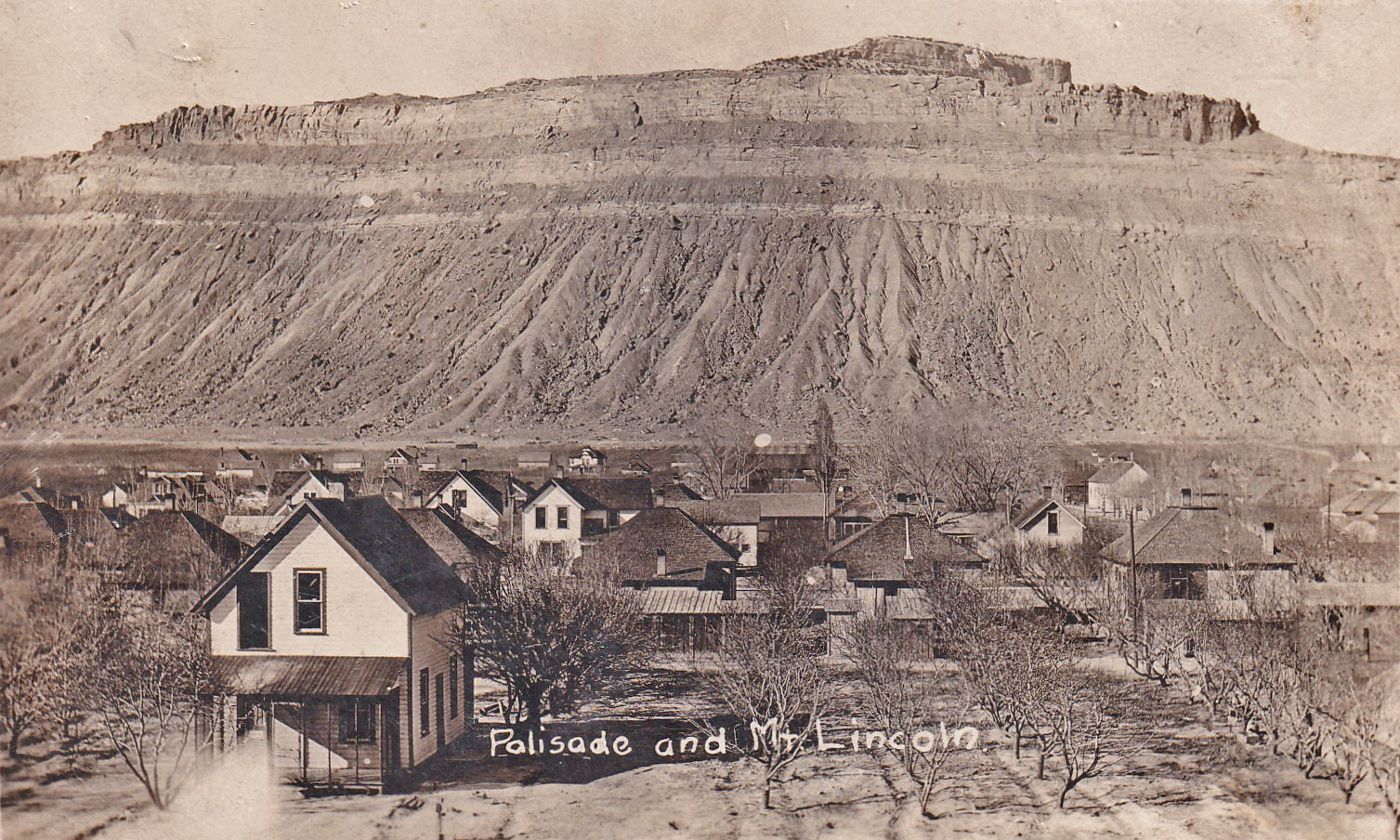
The word “palisades” refers to a line of cliffs, and one look at the striking vertical backdrop in the photo explains the name given to the town of Palisade. (When the Palisade post office opened in January of 1891, the town name was Palisades. In 1904 the town incorporated and changed its name to Palisade.) Palisade sits about thirteen miles east-northeast of Grand Junction. Palisade’s current population is estimated at 2,786.
As indicated in the photo’s caption, the formation behind (to the north of) Palisade is Mt. Lincoln (elevation: 6662 feet). It sits at the east end of the Little Book Cliffs, plateau formations that help define the north side of the Grand Valley, which cradles the Colorado River. (Note: Colorado has a second Mt. Lincoln, a fourteener located in Park County, CO.)
The Grand Valley is approximately thirty miles long and five miles wide, stretching west from Grand Mesa at the mouth of DeBeque Canyon in western Colorado into eastern Utah. It was named for the Grand River, which was the name given to the Colorado River in the late nineteenth and early twentieth century by locals when referring to that portion of the river upstream from its confluence with the Green River.
The location and geology of the Palisade area provide a ten-mile stretch of conditions which protect crops from spring freezes. The result is near-perfect conditions for growing peaches, as well as favorable conditions for the farming of other fruits, wine grapes, and hops. (Note what appears to be an orchard in the foreground of the photo.) Wind moving down-slope from the north is compressed and warmed in DeBeque Canyon, and the cliffs help the process by absorbing warmth. As the wind moves down the valley, it eventually spreads out and its warming effect diminishes.
Utes inhabited the Grand Valley until they were forced out in September of 1881. The first white settler was J.P. Harlow, who established a farm and orchards, diverting water from Rapid Creek via ditch. By 1888, he had harvested over a ton of peaches from his Rapid Creek Orchard.
The two most potent factors in the growth of Palisade were the distribution of its plentiful water supply via canals and irrigation for farming and mining of the abundant coal deposits. Over a dozen coal mines operated in the area until the late 1950’s, when natural gas replaced coal for heating.
I ran across a 1915 Rifle Telegram newspaper article which reminded me that financial bubbles can grow and pop in an agricultural community. The article, entitled “The Curse of Land Booms,” describes the growth of a bubble from 1905 and 1915 in the Palisade area. By 1915, orchard land values had soared as high as $4,000 per acre (over $100,000 per acre in today’s dollars, when adjusted for inflation). The bubble held as long as Mother Nature allowed abundant harvests, but a string of seasons with even partial crop failures brought ruin to people, i.e., “bankruptcy of many a family that prior to moving to the lower valley (i.e., the Palisade area), from Iowa, Kansas and Nebraska principally, was in comfortable circumstances back in those states.” The inevitable chain reaction was reflected in the article’s report that “Hugus & Co. had retired from the banking business in the peach town by disposing of their bank to the Palisade National people.”
REFERENCES:
- Colorado Post Offices – 1859 to 1989, by Bauer, Ozment and Willard, Colorado Railroad Museum, 1990
- CPI Inflation Calculator, U.S. Bureau of Labor Statistics at
- Distance between cities at https://www.distance-cities.com
- “Geology and Paleontology of the Grand Valley,” Museums of Western Colorado at https://museumofwesternco.com/learn/grand-valley-geo-and-paleo/
- “Grand Valley (Colorado-Utah),” www.wikipedia.org at https://en.wikipedia.org/wiki/Grand_Valley_(Colorado-Utah)
- “Mount Lincoln (Colorado),” www.wikipedia.org at https://en.wikipedia.org/wiki/Mount_Lincoln_(Colorado)
- “Mt. Lincoln,” ghikes.com at https://www.gjhikes.com/2009/09/mt-lincoln.html
- “Palisade History,” Museums of Western Colorado at https://museumofwesternco.com/palisade-history/
- Palisade timeline at https://www.historicpalisade.org/wp-content/uploads/2012/09/TIMELINE_small.pdf
- “What is a Financial Bubble?,” oXYGen Financial at https://oxygenfinancial.com/blog/what-is-a-financial-bubble#:~:text=A%20bubble%2C%20in%20the%20financial%20and%20economic%20sense%2C,but%20rather%20by%20the%20over-exuberant%20behavior%20of%20investors.
- World Population Review at https://worldpopulationreview.com/us-cities/palisade-co-population