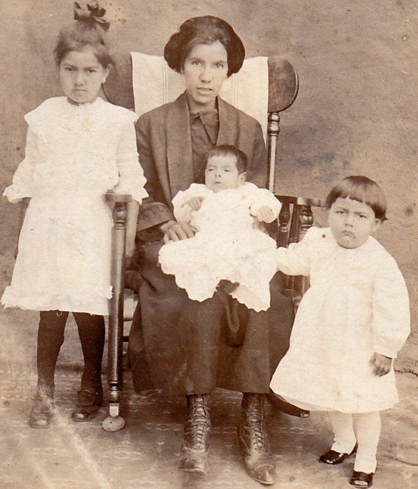
The words “Emiliana Lopez — Garcia, Colo” are inscribed on the back of this postcard. Based on my research, I believe the woman pictured is Emiliana (Ortega) Lopez, born in Colorado on November 20, 1897. Emiliana was one of five children of Encarnacion and Bonifacia (maiden name unknown) Ortega, who hailed from New Mexico Territory and Colorado Territory, respectively. Encarnacion was a sheepherder and laborer.
In 1913, Emiliana married Pedro Jose Lopez, who was born in Garcia in 1895 and, according to Census reports, worked as a laborer and subsequently in construction. They had seven children. Their first three children may be those seen in the picture, i.e., daughter Antonia on the left, daughter Rosita on her lap and son Arturo on the right, born in 1916, 1922 and 1920, respectively.
In 1929, Emiliana was appointed postmaster for the town of Garcia, a position she held until her death in October of 1935 at the age of 38. Her remains are buried at the Garcia Presbyterian Cemetery.
Two years following Emiliana’s death, Pedro married Mercedinia Martinez of Questa, New Mexico, and they had six children. Pedro died in Denver in 1984 at the age of 89.
The town of Garcia, which is in Costilla County, sits just north of the Colorado/New Mexico state line in the San Luis Valley in south central Colorado. To the west of Garcia is Ute Mountain, and to the east is the Sangre de Cristo mountain range. (There’s an irony to Costilla County’s name, for it was originally named for the town of Costilla when Costilla was part of Colorado Territory. However, in 1869, a surveying error was corrected, and the town of Costilla became part of the Territory of New Mexico. The town, which sits just two miles south of Garcia and has been referred to as a sister city of Garcia, now sits in the state of New Mexico.)
Garcia has a deep heritage. It was established in 1849, beginning its life as La Plaza de los Manzanares. According to two different accounts, La Plaza was either named for three Manzaneras families or two Manzanares brothers, who settled in the valley there to farm.
The land that the Manzanares family members settled on was originally a Mexican land grant, specifically the Sangre de Cristo grant. From the 16th to the mid-19th century, Spain and Mexico awarded land grants to individuals and communities throughout what is now the American southwest. The land grant system was developed by Spain but was also used by Mexico to encourage the settlement of its borderlands. At that time, the northern border of Mexico was defined by the Arkansas River, which, to give you a frame of reference, runs through Canon City, Colorado. There were a total of seven land grants awarded by Mexico after 1821 which ended up in current-day Colorado. Three of these lay in the San Luis Valley. These seven grants comprised more than 9 million acres. Per the 1848 Treaty of Guadalupe Hidalgo, which ended the Mexican American War, these lands were all ceded to the United States.
The community of La Plaza de los Manzanares was built according to a plan whereby adobe homes were erected around a central plaza, or square. Several plazas, all with different names, often made up a closely-knit neighborhood. To see an old photograph of La Plaza de los Manzanares, go to the following link and cursor down to page 19: https://www.historycolorado.org/sites/default/files/media/documents/2018/5ct335.pdf.
La Plaza de los Manzanares was renamed Garcia in February 1915 for the two brothers, Guillermo and Agipito Garcia, who petitioned the U.S. government to establish a post office there.
The towns of Garcia and San Luis have vied for the title “longest continuously occupied town in Colorado.” (San Luis is about 18 miles north and a little east of Garcia.) Although San Luis, originally known as La Plaza Media, was established one to two years after La Plaza de los Manzanares, it appears to have won the title because it was officially incorporated by a charter from the Colorado Territorial Government. Garcia, having never received such a charter from the Territory or the State, is unincorporated.
Present-day Garcia and its sister city Costilla in New Mexico have a combined population of about 475 people. In addition to the homes of the residents in present day Garcia, there are abandoned adobe structures there as well, which may include remnants of La Plaza de los Manzanares. One well-preserved remaining adobe structure is the four-room Garcia School, a square building with a pyramidal hipped roof, which opened in 1913 and served Garcia and surrounding communities until 1963. Many of the original materials, including the adobe walls and windows are intact. This rural school was one of 11 in Costilla County. To see a photograph of Garcia School, click on the following link and cursor down to page 20: https://www.historycolorado.org/sites/default/files/media/documents/2018/5ct335.pdf.
REFERENCES:
- 1900, 1910, 1920, 1930, 1940 Census (www.ancestry.com)
- “Appointments of U. S. Postmasters, 1832-1971” (www.ancestry.com)
- “Arkansas River,” Encyclopedia Britannica, at https://www.britannica.com/place/Arkansas-River.
- “Colorado Post Offices – 1859 to 1989,” by Bauer, Ozment and Willard, 1990, published by The Colorado Railroad Museum.
- “Colorado Territory”, Wikipedia at https://en.wikipedia.org/wiki/Colorado_Territory#:~:text=The%20Territory%20of%20Colorado%20was,as%20the%20State%20of%20Colorado.
- Colorado State Register of Historic Properties Nomination Form for the Garcia School, dated June 5, 2015, at https://www.historycolorado.org/sites/default/files/media/documents/2018/5ct335.pdf .
- Distance Between Cities at https://www.distance-cities.com/distance-garcia-co-to-costilla-nm and https://www.distance-cities.com/distance-garcia-co-to-san-luis-co .
- “Incorporated Town,” Wikipedia at
- JRMartinez Family Tree (www.ancestry.com).
- “Life…Death…Iron — Ghost Towns, Road Trips, and Obscure History,” Jeff D. Eberle blog dated April 20, 2020, at https://lifedeathiron.com/2020/04/30/a-ghost-town-a-day-for-30-days-day-30-garcia-colorado-and-costilla-new-mexico/.
- “Mexican Land Grants in Colorado,” Colorado Encyclopedia, at https://coloradoencyclopedia.org/article/mexican-land-grants-colorado.
- “New Mexico Territory,” Wikipedia at https://en.wikipedia.org/wiki/New_Mexico_Territory
- “Sacred Heart Church – Garcia, Colorado, 2016.jpg,” Wikipedia.org at https://commons.wikimedia.org/wiki/File:Sacred_Heart_Church_-_Garcia,_Colorado,_2016.jpg
- “U.S., Find A Grave Index, 1600s-Current,” at https://www.findagrave.com/memorial/146081683/emiliana-lopez
- “Where is the Oldest Town in Colorado? — A History of Settlement in the San Luis Valley,” October 15, 2019, at https://www.historycolorado.org/story/do-you-know-place/2019/10/15/where-oldest-town-colorado
- World War II Draft Registration Cards, 1942 (www.ancestry.com)

